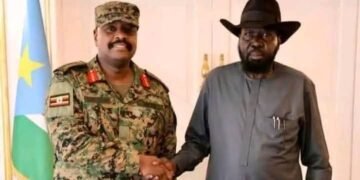


Uganda’s military General Muhoozi Kainerugaba met with South Sudan President Salva Kiir on Saturday in an effort to strengthen a tenuous security partnership following recent violent incidents along the border.
The conversations, described by officials as centered around “cooperation,” come in the wake of a deadly clash between Ugandan and South Sudanese forces in Kajo-Keji County that resulted in multiple fatalities.
The Uganda’s Chief of Defence Forces, arrived in Juba early Saturday morning, where he was welcomed by South Sudan’s army chief, General Dau Aturjong, before heading to the presidential palace for their meeting.
This visit marks the second high-level delegation from Uganda to Juba within a week, following a visit by Deputy Defence Chief Lieutenant General Sam Okiding, who inspected Ugandan troops stationed near the capital.
After his discussions with President Kiir, Kainerugaba met with Vice President for Economic Cluster, Dr. Benjamin Bol Mel, where they addressed issues pertaining to security collaboration between the nations.
Later, Kainerugaba visited Bilnyang village, the operational center for “Operation Milnzi Wa Kimya” meaning “Silent Guardian” in Swahili where Ugandan forces are deployed under a bilateral security framework.
This operation, initiated in March amid renewed tensions between Kiir and his political opponent, First Vice President Riek Machar, has drawn attention and scrutiny regarding its operations and funding.
Recently, the Awan Chan youth group, representing Kiir’s ethnic community, alleged that Ugandan soldiers deployed in South Sudan receive $200 per day, a claim that both governments have yet to confirm.
Historically, Uganda has been a significant security ally for South Sudan, deploying troops in 2013 to support Kiir during a brutal civil conflict against opposition leader Riek Machar, which claimed approximately 400,000 lives before a fragile peace agreement was reached in 2018.
Despite public commitments to cooperation, tensions along the border remain, with a 2022 agreement to demarcate the boundary languishing, primarily due to reliance on outdated colonial maps.


